Thursday, December 4, 2008
Tuesday, November 18, 2008
Westerly action

The NOAA satellite image for the 15th of November. Note the west is covered in cloud but the eastern areas are clear.
Sunday, November 16, 2008
Thursday, November 13, 2008
A couple of vid's from the Seneca
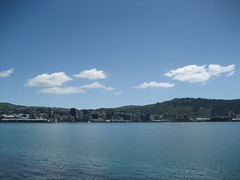
Went for a ride to Tauranga on Tuesday. Here's a couple of videos I took.
Tuesday, November 11, 2008
Flight Rules Y
I had a day-off today so I thought why not go into work and go flying?!? Crazy I know. I'd booked out ZK-MBH for the day planning to do some more IFR flying. I need 50 hours on an IFR Flight Plan before I can teach it. My trip to Christchurch for Labour weekend took 5.5 hours return leaving 19.5 hours more to go (25 hours in a PA28 and then 25 hours in the Seneca V!!). I hadn't been to AR for a while and the weather was looking quite nice so I started flight planning.
As Ardmore doesn't have a VOR or an NDB approach (there are a couple of GNSS approached but I'm not rated and the PA28's don't have GPS's) so there are a couple of ways to get to Ardmore. The first option is to plan to Auckland, fly an instrument approach and then break-off to Ardmore VFR. The second option is to file a "Y" flight rules plan. This is the option I took. It means you file to fly IFR to a point and then continue VFR. I planned to fly IFR to the Waiuku NDB and then VFR to Ardmore. The METAR for Auckland was reporting SCT035, ideal for this flight. So my flightplan was:
As Ardmore doesn't have a VOR or an NDB approach (there are a couple of GNSS approached but I'm not rated and the PA28's don't have GPS's) so there are a couple of ways to get to Ardmore. The first option is to plan to Auckland, fly an instrument approach and then break-off to Ardmore VFR. The second option is to file a "Y" flight rules plan. This is the option I took. It means you file to fly IFR to a point and then continue VFR. I planned to fly IFR to the Waiuku NDB and then VFR to Ardmore. The METAR for Auckland was reporting SCT035, ideal for this flight. So my flightplan was:
NZPM-RUGVI-OR-POKOM-WI-AR VFR
The ETE was 2.3 hours and no alternate was required. We (me and Talbot) got airborne at 1025, heading into the cloud (BKN030) and popped out at around 4500' on the way to 9000' (A090).
 The great thing about having an Instrument Rating is being able to get on top of the clouds. It can be a crappy overcast on the ground but as soon as you get in the air and through the clouds it's a different world. Sunshine, mountain peaks poking through the overcast...marvellous!
The overcast stretched to about OR (Ohura VOR), from there was SCT to FEW. We were making good time with the groundspeed around 115 knots (pretty good for a 23 year old PA28-161!).

 We got a great view of the Kaipara as we overflew at 9000'.

As we got closer to Auckland we started to get vectored around the inbound jets, and finally a vector to the Waiuku NDB and descent to 3000' we were visual. I cancelled IFR and tracked visually to Ardmore.
After a brief stop for a coffee and a toasted sandwich at the Ardmore Cafe (new owners again??!!) we were back in MBH and flew the Waiuku 3A departure bound for New Plymouth. Auckland Control held us down at 6000' until we had passed an inbound opposite direction Air NZ 737. After that we were cleared to 8000' and tracked POKOM-OR-NP.
Overhead Ohura (OR) at 8000' we got handed over to New Plymouth Tower. New Plymouth had been insight since about 30 nm to run to OR so I requested a visual approach. Tower cleared us straight in for runway 23 and gave us onwards clearance to Palmerston North at 8000' via RUGVI.
The leg back to Palmerston North was uneventful. At 20 nm from NP we were handed over to Christchurch, then to Ohakea. At RUGVI I requested a visual approach whihc we got and tracked for a right base for runway 25.
This gave me another 4.9 hours IFR. 10.4 total now, only another 15 to go before I get to do it all-over again in the Seneca. Can't wait!
 The great thing about having an Instrument Rating is being able to get on top of the clouds. It can be a crappy overcast on the ground but as soon as you get in the air and through the clouds it's a different world. Sunshine, mountain peaks poking through the overcast...marvellous!
The overcast stretched to about OR (Ohura VOR), from there was SCT to FEW. We were making good time with the groundspeed around 115 knots (pretty good for a 23 year old PA28-161!).

 We got a great view of the Kaipara as we overflew at 9000'.
As we got closer to Auckland we started to get vectored around the inbound jets, and finally a vector to the Waiuku NDB and descent to 3000' we were visual. I cancelled IFR and tracked visually to Ardmore.
After a brief stop for a coffee and a toasted sandwich at the Ardmore Cafe (new owners again??!!) we were back in MBH and flew the Waiuku 3A departure bound for New Plymouth. Auckland Control held us down at 6000' until we had passed an inbound opposite direction Air NZ 737. After that we were cleared to 8000' and tracked POKOM-OR-NP.
Overhead Ohura (OR) at 8000' we got handed over to New Plymouth Tower. New Plymouth had been insight since about 30 nm to run to OR so I requested a visual approach. Tower cleared us straight in for runway 23 and gave us onwards clearance to Palmerston North at 8000' via RUGVI.
The leg back to Palmerston North was uneventful. At 20 nm from NP we were handed over to Christchurch, then to Ohakea. At RUGVI I requested a visual approach whihc we got and tracked for a right base for runway 25.
This gave me another 4.9 hours IFR. 10.4 total now, only another 15 to go before I get to do it all-over again in the Seneca. Can't wait!
Friday, November 7, 2008
Thursday, November 6, 2008
We've come along way?
I was trawling through the youtube archives yesterday looking for footage of classic airliners. Found a Pathe Newsreel of the Bristol Type 167 Brabazon. The largest aeroplane for it's time.
Tuesday, November 4, 2008
Where to next?
I've got my thinking cap on, trying to decide where to fly to IFR next. I'm thinking north would be good. Maybe Tauranga or Gisborne. That should chew up some hours.
Monday, November 3, 2008
Wednesday, October 29, 2008


A bit of IFR
It was a long weekend, Labour Day and all that. I thought it might be a good idea to do some "real" IFR flying as I need 50 hours on an IFR flight plan before I can teach it. They let me take ZK-MBC away, the same aircraft I did my renewal in.
Christchurch was my planned destination, being my home town (one-eyed Cantabrian!). I settled on the following route as it had the most direct routing, MSA's that weren't too high (apart from one leg) and it was mostly a VOR route:
Christchurch was my planned destination, being my home town (one-eyed Cantabrian!). I settled on the following route as it had the most direct routing, MSA's that weren't too high (apart from one leg) and it was mostly a VOR route:
NZPM-OTAKI-WN-KAMES-WAIMA-KI-STONY-CH-NZCH
The total distance was a tad over 230 nm and the EET was 2.10 hours based on winds from the Friday night ARFOR's. I planned on departing at 0700 Saturday morning. Simon and his Mrs hitched a ride too so we were fairly heavy.
The TAF for CH showed BKN006 and OVC010 but it looked pretty good enroute. My only concern was the freezing level which was 8-10000 ft through the SA, DV, ST, KK and PL area's. If there was no cloud it wouldn't be a problem. A quick check of the Radar for CB's and we were out of PM bound for CH!
After 40 nm of climb to 10000' (A010) MBC settled in the cruise. We were IMC and had been since about 6000' in the climb. Frequent SADIE checks were the call of the day as the OAT was reading 0-2 degree's. The DME was showing 85-95 knots GS, those winds were different to what was advertised!
Overhead WN VOR, Twiddle, Turn, Time, Talk and on to the next waypoint (KAMES). A little bit of ice was starting to form on the temperature probe. Icing will always adhere to the sharp, pointy objects first. Another few SADIE checks! We were indicating 90-95 knots so we weren't going too bad considering the draggy airframe that MBC has. as we got closer to KAMES we got a bit of ice forming on the leading edge. It was minimal but I tought we'd better get down a little lower. I requested and got 9000' non-standard and also got Radar Terrain on the KAMES-KI leg as the MSA on that leg is 9200'. It was fairly quiet on WN control so they were quite helpful.
As we neared KI (Kaikoura NDB) the clouds parted and we could make out the Kaikoura Ranges. We were probably around 500' above a layer of Alto-stratus. At 60 DME from CH I requested descent. He got us down to 6000' which relaxed me somewhat as I saw the OAT increase to 4 degree's.
The CH ATIS was reporting BKN006 and OVC010, the same as the METAR had said. I briefed myself for the VOR/DME 20 approach. My track was 196 to CH and the final track was 197 so we were pretty much on a 40 mile final for runway 20! CH Control got us to change to Approach on 124.1. As soon as I'd established contact with them a new ATIS was issued. It was now reporting BKN009 and OVC010. Nice(r)! Cleared direct to OD NDB and down to 2000' he cleared me for the VOR/DME 20. I called CH Tower after I'd established on finals. At 7 nm out they cleared me to land. After briefly skimming across a layer of Stratus we were back in the muck for 1100'. Finally at 3 nm and 900' I was visual. CH's big, long runway was ahead of me and all the runway lights were on. An awesome sight!
Tower cleared me to taxi to the aero club which was looking pretty dead. My stomach was grumbling and all I could think about was breakfast. I had a booking at Drexels (Farmers Breakfast, yum!!).
The flight took 2.9 hours with 2.6 hours actual IMC. No wonder I was buggered!!
Tuesday, October 21, 2008
Crossing the Strait

Almost at the South Island! En-route to Woodbourne from Palmerston North. The Brothers on the right.
Long finals for 24 at WB, Omaka on the right.
Move to Blogger
I thought I'd move to Blogger as I was finding Wordpress a little restrictive. So here I am!
Subscribe to:
Posts (Atom)